Here's a undated travel brochure from my collection that fits in with my current blog theme of summer fun up here by the lake. It describes the Lake Erie Vacationland region. (I know, I'm straying outside my blog's "Lorain County" theme again!)
Before I picked up this brochure, I thought "Vacationland" was some ad man's recent creation, probably because I had seen signs for the Vacationland Credit Union and assumed it was just some catchy name.
It wasn't until I acquired a copy of Lake Erie Vacationland in Ohio that I learned the name had been around a long time. The book is a reprint of a 1941 travel guide that was part of the Ohio Writers' Program of the Work Projects Administration, designed to give writers, editors and researchers some work during the Great Depression.
The book defines Vacationland in its very first paragraph:
The traveler following State 2 over the monotonous farm land east of Toledo, or US 6 along the lake west of Cleveland, soon enters a region unlike any other in Ohio. It is made up of both land and water. Sandusky Bay is as much a part of it as Lake Erie; two long peninsulas jutting into the lake offer extraordinary surprises; and a few miles to the north are celebrated islands and fishing grounds. The region can be accurately spotted on an Ohio road map. The neat quadrangle formed by drawing straight lines between Vermilion on the east, Norwalk on the south, Toussaint Creek on the west and North Bass Island in Lake Erie embraces all the area known as Lake Erie Vacationland.
Anyway, the Vacationland map (shown at left) is one of those that are a lot of fun to look at, with plenty of tiny cartoon images sprinkled throughout. Unfortunately it is printed on super strength paper slightly thinner than plywood, making it tough to wrangle onto a scanner. I can only imagine trying to navigate with this thing in your car!
But I did manage to scan a few chunks of it, folds and all and piece it together. Here's a portion showing Cedar Point (with no Causeway) and the old Bay Bridge across Sandusky Bay (that preceded the Thomas Edison Bridge). (Click on it so you can navigate around!)
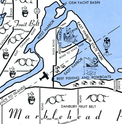
And here is a close-up of another part of the map.
It shows an area that was a favorite of my family, Marblehead and particularly East Harbor State Park. East Harbor had (and has) a great beach and was a good place to set up the old trailer for some camping fun. And after looking at the map, I now know that there is a West Harbor too!
****
Incidentally, to visit a terrific blog by the Sandusky Library Archives Research Center dealing with Vacationland and many, many other historical topics, click here. It's got tons of fascinating archival photos and is well worth the visit!
Thursday, July 29, 2010
Subscribe to:
Post Comments (Atom)


No comments:
Post a Comment